The Department for Energy Security and Net Zero (DESNZ) takes the lead in the UK in preparing the annual Inventory of Greenhouse Gas Emissions for the United Nations Framework Convention on Climate Change (UNFCCC). DESNZ contract Ricardo Energy & Environment (REE) to compile the overall greenhouse gas emissions inventory and they in turn subcontract the UK Centre for Ecology and Hydrology (UKCEH) and Forest Research (FR) to prepare the data relating to Land Use, Land-Use Change and Forestry (LULUCF) in the UK.
 This report is prepared in order to describe the method used to spatially disaggregate the emissions and removals in the LULUCF sector to enable the compilation of LULUCF estimates for local authorities as part of DESNZ’s assistance to local authorities in tracking progress on decarbonisation.
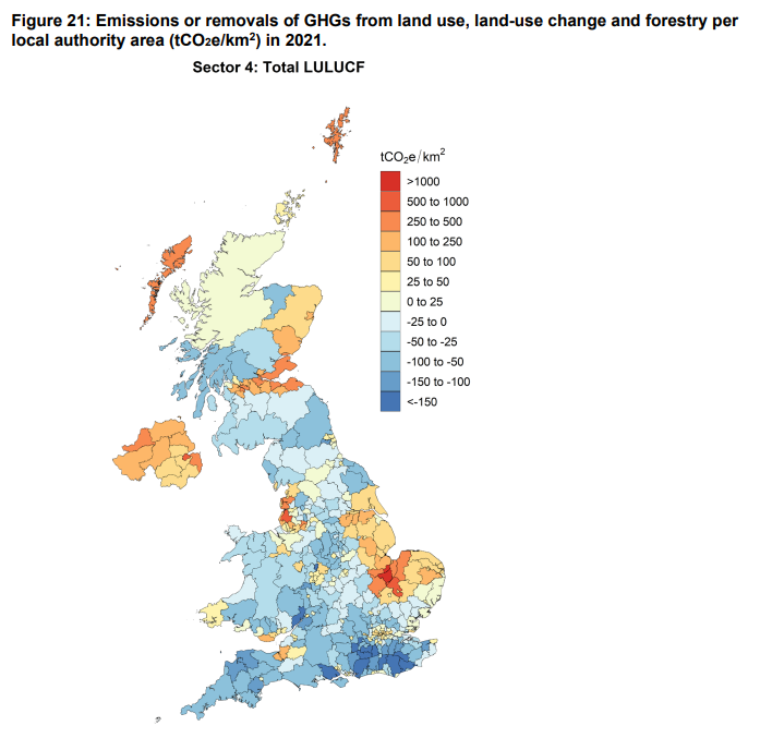
The LULUCF data reported to the annual inventory is prepared in accordance with the reporting requirements of the UNFCCC. These estimates are made using dynamic models of changes in stored carbon, driven by land use change data. For forestry, the CARBINE model (developed and run by FR) deals with plant carbon, dead organic matter, soil carbon and harvested wood products and is driven by the area of land newly afforested each year, management practices and harvesting. Changes in soil carbon are driven by estimated time series of land use transitions between grassland, cropland, forest land and settlement land uses. These models, and those for other LULUCF activities (e.g. nitrogen fertilisation of forest soils, drainage and rewetting of organic soils), are run for each of the four countries of the UK to report emissions and removals of greenhouse gases (CO2, CH4 and N2O). Until the 1990-2004 inventory (submitted in 2006) no data were reported in map format at a scale below the devolved administrations (England, Scotland, Wales, and Northern Ireland); here we report results from methods to provide estimates of LULUCF emissions and removals at the scale of local authorities within the UK for the 2021 inventory year (published in 2023).
The LULUCF sector differs from other sectors in the Greenhouse Gas Inventory in that it contains both sources and sinks of greenhouse gases. The sources, or emissions to the atmosphere, are given as positive values; the sinks, or removals from the atmosphere, are given as negative values. The values reported here are given as net emissions/removals, i.e. the sum of emissions and removals for each category.
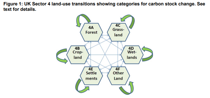
Different activities are associated with each land use or land-use change. For example, ‘afforestation’ refers to all land-use change to Forest Land, ‘drainage’ activity can relate to Forest Land, Cropland, Grassland, Wetlands, and Settlement. ‘Peat extraction’ affects Wetlands. The change in carbon stocks of living biomass, dead biomass, and soil organic matter must be reported for each activity together along with other relevant non-CO2 gases (i.e. CH4 and N2O).


 Guest preview of selected publicly available resources